
In the early 1970s I attended East Anchorage High School. We had in most of our classrooms one or two old desks with a foot missing or a leg bent a little, pushed off in one corner. At least several times during any school year, in some quiet moment in the class period, we could hear those desks rattling and bouncing off the floor. That’s because Anchorage has always experienced earth tremors, and we took them for granted. At most, we would glance at each other and grin — “Did you feel that?”
For hundreds of miles around, but particularly in the highly civilized City of Anchorage, no one failed to notice the shaking on Good Friday 1964. According to witnesses, it started rather gently for a few seconds, then shifted into high gear with visible shock waves rolling through the area. The ground literally undulated and rolled, as if it were Jello. One woman told me how she watched out the window as a thick sapling in her yard slapped the ground on two sides, alternating back and forth. Whole buildings simply dropped into the ground a full story, while others tipped over and slid or outright tumbled into huge gaps that opened in the ground. Down near the epicenter of the quake in the Port of Valdez, the 10,000 ton SS Chena cargo ship bounced off the bottom of the bay several times, smashed the dock and finally ended up on dry land.
The rippling ground waves hit as far away as Texas, where the earth jumped four inches (10cm) in some places. The resulting tsunami wiped out at least one whole town in Alaska, and dropped portions of many villages into the sea. As far away as Crescent City, CA there were a dozen deaths from the tsunami. Some 20 hours after the first shock, a two-foot wave lapped the shores of Antarctica.
If you recall the map from the previous lesson, how the upper layer of the massive stone shield cracked, you won’t be surprised to find that the portions outlined in red and blue shifted laterally to the southeast as well as vertically. Survey markers were found several feet away from previous locations. The aftershocks continued for 18 months locally, while the shockwaves bouncing around inside our planet rattled the seismographs for quite some time, much like a bell ringing and continuing to hum long after the last clap.
The fracture occurred on a fault line, of course, and about 25km deep. The term “epicenter” means above or over the center (the Greek prefix epi), the spot on the ground atop the deep fracture point. The actual slippage lasted 4 minutes 38 seconds of some of the hardest rattling ever recorded by modern instruments (9.2 on the scale). Scientists have detected four kinds of waves they can measure coming from an earthquake.
The first two are detectable with seismographs anywhere, because these waves travel through earth itself as a whole. First are Primary or “P” waves. This is that compression wave we covered in the first lesson. This kind travels the fastest and passes right through the earth so that the seismographs placed to detect nuclear weapons in places like India and South Africa got a straight-line effect from P waves. They would have attenuated to the point only good instruments could pick them up, but of course, all over that part of Alaska such waves were distinctly audible and tactile. Different frequencies travel faster than others, which is why some animals will react and even panic before humans can sense them.
Then there are Secondary or “S” waves. This is outright shaking, both vertically and horizontally. They are a slower than P waves, and it requires a mathematical formula to track the widening gap as the waves travel farther. It’s an indicator of distance from the seismic monitoring station. These waves travel through solid ground, but not liquids. This is how we discovered that some portion of the earth’s core is liquid, because the S waves from this earthquake didn’t go through the middle, only through the margins of the earth’s outer core where it’s solid.
The other two waves are Raleigh and Love waves, which transmit only through the surface and locally. To be honest, you and I cannot tell the difference between them, though instruments can; you can look them up here. The point is that they radiate out from the epicenter like ripples on a pond, with both vertical and horizontal motions. These waves are typically much bigger than than S waves, and this is what does most of the damage we see.
But apparently the P and S waves did something no one could have expected, and was understood properly only in retrospect. You see, Anchorage is a city built atop one of those few shelves of alluvial soil carried down off the mountains in that part of the state. This platform juts out into Cook Inlet; it’s a port city. As you might expect, there are several layers of different kinds of material, topped with the ubiquitous tundra — rich black loam with spongy plant life growing on it. It’s amazing how, even with very tired feet and legs from hiking, stepping on that stuff breathes new energy into your body and you forget the pain. Granted, in a modern city like Anchorage, you can expect folks to scrape that stuff off, dump topsoil on it and plant grass and trees. Under that tundra, though, is a heavy layer of broken rock and gravel and it looks like it goes down forever in some places. Below that is a peculiar layer of something else.
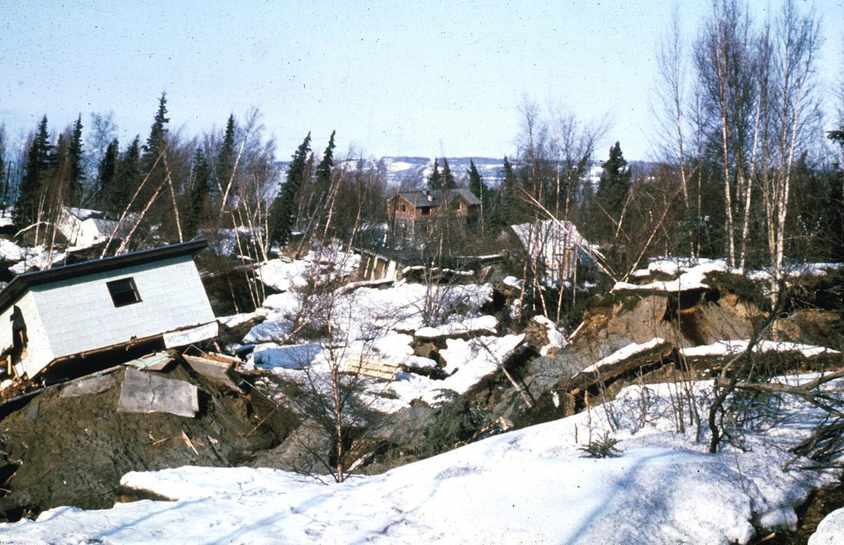
Turnagain Heights
Somewhere around 50 feet (15m) deep is a fat layer officially called Bootlegger Cove Clay. Whole sections of the city stood above this stuff. One neighborhood out on the edge of this flat shelf was called Turnagain Heights. When the P and S waves hit this place, that Bootlegger Cove Clay turned into mush, just short of liquefying. It oozed out of the face of the expose shore bluff onto the beach very quickly. All the soil above it just collapsed and leaned over at all angles. One of the first trips we took when we arrived in Anchorage was to Earthquake Park on the beach near Turnagain Heights. There were huge columns of free-standing earth out on the beach, some 20 feet high with little trees still growing out of the tundra crowns. They stood because they had been isolated pockets with no clay underneath. We managed to climb up on a few of them. They’ve all dissolved since then, but it was quite a mind-trip for the ten-year-old boy I was then.
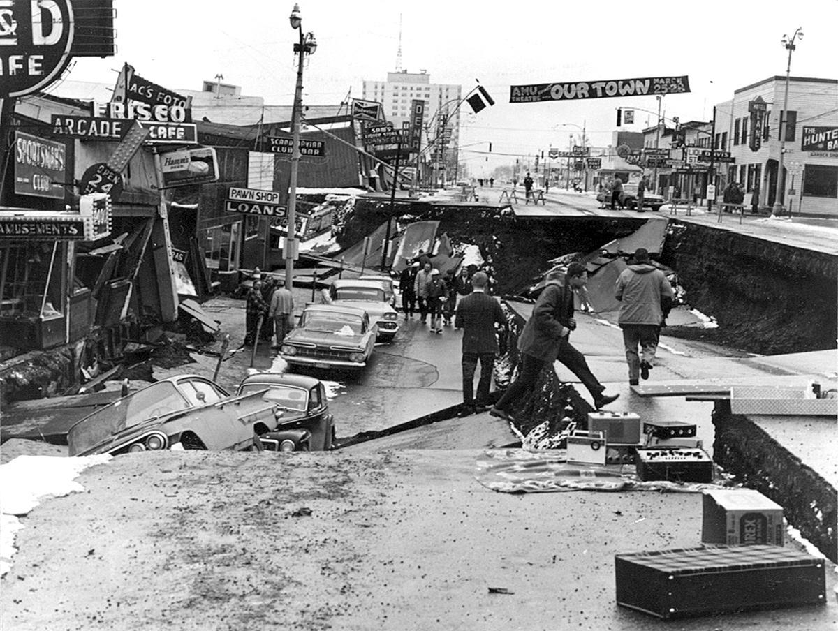
Downtown Anchorage
But it was the surface waves that did the most damage. It gave rise to new building code in the city and some unique technological advances in building construction. Right after the earthquake, a 15-story tower went up with a different type of foundation, incorporating a layer of Teflon so as to ride above some of the lateral shaking. Sometime later a lesser, but still pretty rough, quake hit the city. The tall tower rode it out fine, but an older and shorter office block next door, with a traditional concrete footing, rocked back and forth and slapped the side of the safe tower repeatedly, hard enough to damage both buildings.
In a broad survey statewide, the vast majority of damage to human infrastructure was from the collapse of bluffs. Some fell into harbors and required dredging, while others buried or pushed villages out into the water.
Finally, I want you understand something about the tsunami. The ocean floor near the Aleutian Trench popped up as much as 35 feet in some places, but generally 10 feet across this whole 600 mile stretch, about 50-100 miles across. That’s an awful lot of real estate shoving some really deep water away. Have you ever tried to pick up an inflatable wading pool on one side to dump it? That two inches of water suddenly becomes several gallons on the far side of the pool. We are talking several hundred cubic miles of water being shoved around here, and all at once in just a matter of minutes. It’s not the height of the wave out at sea, but the volume of water being moved that is so destructive.
On top of that, the undersea landslides along that same trench added to the displacement of water. And a bunch of other smaller landslides all around the numerous bays in that region each had their own little tsunamis, sometimes adding to the bigger one.