
Our hand-n-arm model in the previous lesson oversimplifies things, of course.
If you went out to the subduction zone off the southern shores of Alaska, and took a submarine down into the ocean to look at it, you wouldn’t see much. The ocean floor is covered in silt and other sorts of debris. What you would see is that muddy bottom dives deep into what we call the Aleutian Trench. It’s the spot where the two tectonic plates come together as the North American plate rides up over the Pacific Plate. While the Pacific is shoved down, it curves down a bit, but the ragged edge of the other plate is curled under. The top layer of the earth’s crust, at least in Alaska, is much stiffer than what’s below it. You aren’t likely to see the glacial movement of the earth’s crust because it’s such small increments over such a massive scale.
Sometime over the past few centuries, there was a 600 mile arc where the two plates caught on each other. The pressure began to build. It works best if you envision that state of Alaska as one massive stoneware plate. If you actually spent some time in Alaska, you could readily see that the whole state is just a bunch of mountains with a thin cover of alluvial deposits here and there. The thickness of this underlying stone shield varies, as does the density and composition, but it’s still pretty much one big piece. On that massive scale, it can flex a little, but not much.
As the southern edge of this stone shield was pulled under, it didn’t curl easily. The stress was spread northward more than 300 miles. So for a couple hundred of those miles, the surface of the stone shield was bent down lower than normal. A hundred miles or so farther north behind that dip, it was bulging upward. This big plate wasn’t quite stiff enough to tip the whole thing up off the earth’s mantle, but the pressure was trying to do something like that. The rest of that massive stone shield was just too heavy. Sooner or later, something had to give. Instead of popping loose at the edge where all the action was taking place, it broke up in the deepest corner of this arc.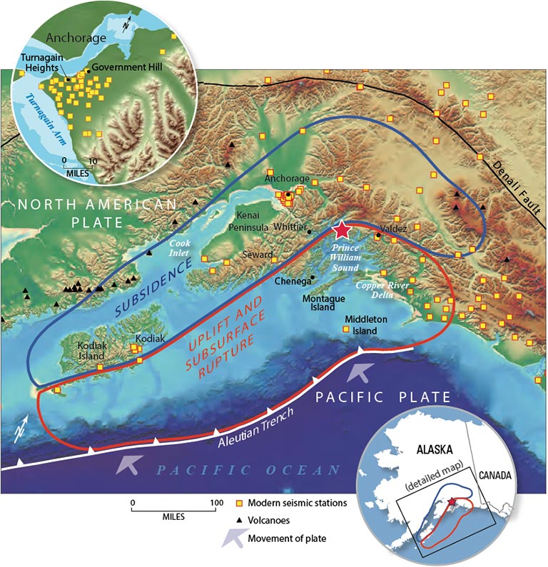
That break was just enough to let the pressure off so the plate could shift around just a little. The part that was bent down came loose from the catch and popped back up to its normal place, and the bulging part farther back from the edge fell back down into its normal place. That explains the image here that I borrowed from the USGS, mapping some aspects of that Bad Friday Earthquake. You really should click on it to get a closer look at the details (CTRL-click to open it in another browser tab). The red star over Prince William Sound is the breaking point, the epicenter of the actual earthquake.
American colonization of Alaska took place long after this pressure began building. They invested a lot of resources in infrastructure that was actually resting on a time bomb they couldn’t possibly know about. So from their point of view, a big chunk just popped up out of nowhere, but the part they were living on is what dropped down. It made a terrible mess of all that stuff they had built on the Alaskan rock and soil. Anchorage was the biggest improved area in those parts, and it suffered massive damage. It’s not that the rest of this area didn’t see some radical changes, but so very much of this state is not actively used by humans, so you aren’t going to read about the parts where people rarely set foot.
As you can see from the map, earthquakes don’t always center right on top of the subduction zone where you might expect them to be.
I, too, have been interested in/fascinated by earthquakes since i was a youngster. Living on Saipan in the Mariana Islands when i was little presented us with occasional earthquakes and tidal waves (tsunamis now) in the area. So because of that interest, i requested and receive earthquake emails from the USGS if they are greater than 6.0. Those of lesser magnitude are so frequent throughout the world that i would be getting notifications by the minute!
I appreciate your method of explaining the activity. For those who are not “students” of seismological activity, it helps one to understand the underlying mechanisms at play.